Thursday, July 28, 2011

Old River Trail, Buffalo River - July 1-3, 2011


With a little planning ahead, I was able to get my friend, Jeremy, to join me on another backpacking trip at the Buffalo River. We chose this location again due to the fact that it is named a "River" and therefore should have water to drink from. Most places around Northwest Arkansas dry up this time of year and you have to pack in a lot of water.  I'm trying my hardest to keep my pack weight below 30 lbs these days, so that didn't sound very appealing to me, so we chose the Buffalo.

We decided we were going to start the trip from the Horse Camp at Steel Creek again.  We wanted to go further than we did last time, so we decided to leave the other vehicle in Erbie.  Looking at the map, it looked like the quickest and best way to get to the Erbie parking area was to go through Compton and down Compton Road to the parking area.  However, once we got a mile or two down Compton Road, it became evident that we had stumbled upon a 4-wheel drive adventure.  Due to all of the rain that we received in the spring, the steep downhill road had been completely washed out leaving embedded boulders sticking up out of the ground that had to be navigated over and around.  This process took quite a bit of time, but we finally got to the bottom of the hill that the road was leading us down and to the parking area.  Of course, as soon as we had parked my truck and loaded my gear into Jeremy's truck, we turned around to see a well maintained road leading out to the main highway.  Jeremy quickly made up for lost time by rocketing down the road and back over to Steel Creek. 

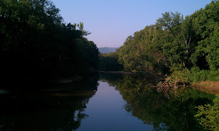
We hit the trail sometime between 6 and 7 PM and hiked about a mile down the trail to the second river crossing.  On our last trip, we had scoped this area out and deemed it as an excellent place to camp.  We were now taking advantage of our previous reconnaissance and setup camp right next to the river. 


We had already eaten dinner on our drive in, so we had some free time before it got completely dark to do some fishing.  We caught a few small fish here and there and had a good time.  We decided to get a fire started since we had an awesome campsite and a lot of wood available to burn.  We let the fire burn down and headed off to bed.  While laying in our tents, Jeremy started hearing the animals stirring around us -- he apparently isn't too fond of critters.  A few minutes later we heard coyotes start howling in the distance and he was like, "I'm getting my knife...I'm going to sleep with it."  It was very humorous!

The next morning, we got up about 5:30 AM and made a quick breakfast of oatmeal, tore down camp, packed everything up and started down the trail.  We wanted to get a good start before the temperatures got up too high.  We made good time down the trail.  It was amazing to see the difference in plants around/on the trail from our trip back in the spring.  There were some sections of the trail that were almost completely overgrown.  The other huge difference were the horse flies!  They were everywhere and very annoying!

We came up on the Jim Bluff section of the trail and did some more reconnaissance.  It started out as a hunch on how we could skip a river crossing and ended up being a discovery of another very nice future camping location as well as a fishing break. As we were looking around, we found a very deep pool right below Jim Bluff that had some very good size small-mouth bass in it.  Of course, we had to stop and fish the hole -- temperatures or no temperatures!  :)

Jim Bluff Marker

Good Future Campsite


After our fishing break, we hit the trail again and it wasn't very long before we got to Horseshoe Bend again.  It was completely amazing to see the contrast between spring river levels and summer river levels.  The river was more like a creek around the bend this time around (versus the fast current river that we saw in the spring).  A short time later, we came up on Kyle's Landing which is another established campground (costs $10 to camp/night).  We decided to take advantage of the toilets there as well as the running water. 

We took an extended break here while we decided whether or not to setup camp here or go further down the trail.  We decided to head down the trail and see what was down there, and worst case scenario, we could always backtrack and setup camp at Kyle's Landing.  So, we took off down the trail again and found a good fishing/swimming hole pretty quickly, but it didn't really have anywhere to setup a tent, so we had to move on.


About another 1/2 mile down the trail, we found a spur that lead down to the river.  We decided to check it out and found another awesome campsite right next to the river.  The actual campsite was back under the trees, so it was shaded.  The river was low enough that there were some shoals along the river that made an excellent loacation to leave our boots out to dry in the sun (we had gotten a little impatient with the river crossings and just started walking across the river instead of trying to stay dry).

As soon as we decided that this was going to be where we setup camp, our packs came off and we headed straight to the deep pool in the river to go swimming (it was nearly 97 degrees out by this time of day).  We swam for awhile and then got out to go cook and eat lunch.  We were very impressed that we had made such good time and got to the campsite before lunch!  We had some of Mountain House's Dehydrated Beef Stew -- it was very delicious!

Swimming in a Deep Pool
After lunch, we setup our tents and then decided it was time for another swim!  It was a beautiful section of the river -- directly below a 2,000+ foot bluff with some very deep pools to swim in!  The water temperature was very cool once you got in to about 3 foot deep.  There were several large rocks in the river that made good jumping boards as well!

After swimming for awhile, we decided to check out upstream and downstream a little ways to look for good fishing holes.  We found a few spots downstream that looked good for later that night -- closer to dusk.  While we were scouting out the area, we found a baby snapping turtle that proved to be some entertainment for a little while.

We made our way back to our campsite and decided to swim for awhile again, but before we had a chance to do so, a thunderstorm started blowing in and we decided we should probably get our rain flys on the tents before our gear got wet.  We got a little bit of rain, but that was it.  It stayed overcast for the rest of the day (which brought the temperatures down some).  We swam some more during the afternoon, and even took a nap next to the river...until Jeremy's snoring woke both of us up!  :)

After dinner, we went fishing and had some luck -- nothing big, but a lot of fun none-the-less.  We went to bed rather early that evening as we were wore out from the day's activities.  The next morning, we got up and did the normal routine of tearing down camp.  Both of our phones had died (hence the lack of pictures in this part of the post...sorry - we'll do better next time!), so we really didn't know what time we left.  Our best guess was probably around 7:30 or 8:00 AM.

We continued down the trail and quickly made it into the Boy Scout Camp -- Camp Orr.  The trail actually follows one of the roads through the Boy Scout Camp and made for a very quick hike.  After that section, the trail was even less maintained (probably due to decreased traffic).  We kept going and finally made it to our last river crossing.  From here we had to climb up a short bluff and then hike across a field with waist deep grass.  We finally made it back to the truck and discovered that the time was 8:30 AM!  We had to have left closer to 6:30 or 7:00 AM.  It was a good hike and we definitely agreed that our next trip needed to be even longer -- possibly the rest of the trail.

Wednesday, July 27, 2011

Pigeon Roost Trail - Hobbs State Park - June 18-19, 2011

Pigeon Roost Trailhead

My next trip was a shorter fun trip on which I took my oldest son with me again.  I decided to tackle a shorter trail this time with him in an attempt to give him a more positive backpacking experience (better than the 15 mile long Butterfield Trail).

We got started at about 2:00 PM to make our 4 mile hike back to the primitive campsites. It was a really hot day (like in the mid-to-high 90's) and I was glad that I had went ahead and purchased water bladders for us to use for this hike.

The really cool thing about the Hobbs State Park area is that there is evidence of Native Americans all over the place.  The picture here is a tree where the Native Americans had tied it when it started growing in such a manner to mark the trail head down to a water source.

Indian Trail Marker

The trail is well maintained and easy to follow.  There are several access points to Beaver Lake throughout this trail.  One of them is a beautiful vista area where they have actually installed park benches to allow everyone to sit and enjoy the view.


There were a few sinkholes alongside the trail to the campsites.  I'm not sure why, but from this point onward to the campsites, the horseflies were terrible!  They kept bugging us regardless of bug spray or other remedies.

Large Sinkhole Alongside the Trail


The primitive campsites are about 4 miles in on the loop -- regardless of which direction you go.  The campsites all have established pads to setup tents on.  We stayed at campsite 3 which had two different pads and an established fire pit.  The new two man Kelty Grand Mesa 2 tent that I bought for this trip was slightly too large for the pad, but we made it work.

Campsite #3


When we first got into our campsite, we heard a lot of rustling in the brush just beyond the campsite.  After a little investigation, we found that it was two opossums digging for food.  Since I'm not too fond of opossums, we threw rocks towards them and "herded" them off.  We had fun playing some games at camp, and then made dinner.  After dinner, we went down to the lake to wash up and to refill out water containers with filtered water.  We came back to camp, made a fire in hopes that the smoke would help with the mosquitoes that were sucking blood like vampires!  :)  After the fire burned down, we went to bed even though it was incredibly hot!  I considered several times throughout the night about taking down the rainfly, however, we could see thunderstorms on the horizon and I didn't want to risk getting rained on.  After awhile, it cooled down enough where we could sleep comfortably for the night.

The next morning, we got up, had some oatmeal, and then tore down camp.  We then hit the trail and made pretty good time.  My son had a lot of fun and even found a box turtle crossing the trail.  This trip was a short one (8 miles in total), but it was good trip for my son to get his feet wet with backpacking.


Monday, July 25, 2011

Butterfield Trail - Solo Trip - May 14-15, 2011

After completing the Old River Trail at Buffalo River, I was excited to tackle another trail.  The only problem was that we got tons of rain -- as in massive flooding throughout the entire area.  After the rain stopped and the flood waters had gone down, I decided to take the Butterfield on again solo since Jeremy was not available.

After registering for my backcountry permit, I drove over to the trailhead.  I instantly saw signs of damage from all of the flooding -- the bridge over Lee Creek was closed and had debris stuck in it from the current.  There was also planks missing from the bridge making it completely impassible.  Since I was going to be hiking the trail counter-clockwise (again), I didn't worry too much about it but knew that it would be a problem for my return trip.


I hit the trail about 12:30 PM and had a huge climb ahead of me due to hiking it in the direction that I chose. Once I made it up the large climb, I took a quick break and then continued down the trail.  It didn't take long for me to encounter about a mile section of trail that had been deeply damaged by the flood.  There was several sections of trail that had slid down from the rest of the trails by up to 3 feet:


Butterfield Falls was flowing at a steady rate making the climb down a slippery one.  After getting down the falls, it was a quick hike to the turn off down to Junction Camp.  This time, I decided to continue hiking and get all the way to Rock Hole Camp to spend the night which is slightly over 1/2 way around the loop.


Rock Hole Camp was actually pretty crowded on this trip -- there were three other groups that stayed the night.  There was evidence of a lot of flooding all around the camping area and especially in the creek bed that was still very full of water.


The next morning, I ate some oatmeal for breakfast, tore down camp, and hit the trail.  Being over 1/2 way around the loop, I was feeling pretty good continuing the remainder of the hike.  I had packed an extra meal for lunch but never got to use it since I was finished with the hike right at noon.


This ended up being a quick little trip, but was still a lot of fun.  It is becoming apparent that my backpacking skills were improving.

Saturday, July 23, 2011

Buffalo National River - April 1-3, 2011

Buffalo National River: Miles and miles of backpacking trails, canoe ready river, and beautiful bluffs the whole way.  This trip was the first backpacking trip that I made along the river and as such made it with my good friend Jeremy.  With my new gear packed and ready to go, we headed down to the river after we got off work.

We got to the Horse Camp at Steel Creek where we intended on spending the first night.  What we didn't know was that it costs $10 to spend the night at this camp and we, of course, did not have any cash.  We decided that we could setup a small camp in the parking area for the Old River Trail and wouldn't have any problems as long as we were up early enough to tear down camp.

Horse Camp at Steel Creek

 Unfortunately, we were wrong.  The camp host came around at about 10:30 PM and informed us that we needed to tear down camp and move outside the Horse Camp -- at least 1/2 a mile outside the horse camp.  So, at 10:30 PM, we had to tear down camp and move outside the camp.  We only had two options -- one was to go ahead and make the first river crossing and start down the trail, or to hike up the hill behind the Horse Camp to find a new area to setup camp.  Given the time of night and limited visibility (due to the darkness), we decided to find a new area to setup camp behind the Horse Camp.  We found a flat area that was clear of brush and setup camp -- what we failed to realize was that we were less than 500 yards away from the Horse Camp (a lot less than the 1/2 mile requirement).  It was very late before we were able to go to bed that night and it got very cold that night -- the new mummy bag came in very handy in keeping me warm that night.

Beautiful Fog Covering Bluffs Around Horse Camp

The next morning there was a very beautiful fog over the bluffs surrounding the Horse Camp.  We ate some instant oatmeal for breakfast, cleaned up, and then hit the trail.  As soon as we had taken about 3 steps into the river for our first river crossing, we both immediately agreed that we were glad we weren't doing this in the dark!  Since we were hiking this trail in the spring, the river was pretty deep -- nearly 3 feet at some crossings and it was flowing at a very quick rate!  A lesson that I learned about river crossings is that you need proper footwear to safely cross the river.  I had decided before we left that in the name of being lightweight, I was going to take a pair of flip-flops to use for the river crossings.  This sounded good in theory until the flew off my feet in the middle of the river and I was left will having to cross the river barefoot!  This particular trail crosses the river about 10 times.  The other challenge that backpackers face while crossing the river is that the Old River Trail is also a horse trail and as such, you have to yield to horses crossing the river too -- even if you are in the middle of the river.  As we hiked further along the trail, there were several signs that during a good flood, that the water levels would be well above our heads on this trail.

Evidence of Possible High Flood Waters
Some River Crossings Were Very Deep


There were several old shelters and in some cases an entire old homestead on the side of the trail.  These were fun to explore as we came upon them.  


An Old Shelter of Some Kind
Another Temporary Shelter of Some Kind

 
We made good time and setup camp at a section of the River called Horseshoe Bend.  This is a section of the river that makes a big upside-down U shape with a chunk of land between the "legs" of the U.  The water got very deep at some points of the U and what was very entertaining was all of the canoes that seem to tip over at this point.  Even more entertaining where the ones that tried to flip the canoe back over in deep water by trying to lift up the canoe.  We were lucky enough to find a campsite that already had a good pile of firewood just waiting to be burnt...and of course, we had to burn all of it! :)  After we setup camp, we had plenty of time to fly fish the river around us.  I got lucky and pulled out a good size small-mouth bass!

Camp at Horseshoe Bend


The next morning we got up and headed up the Hemmed In Hollow trail to see the Falls.  Apparently, this is the tallest waterfall between the Rockies and the Appalachians.  It was pretty impressive with how tall the falls were -- it would have been more so if there was more water actually coming over the falls.

Hemmed-In-Hollow Falls
The Falls were cool, however, it also meant nearly a 2,000 foot change in elevation over the next 2 miles in order to get back to the truck.  This elevation change was mostly a stair step climb at several points making it even more challenging!  To top it all off, this was also the first day of the year that the temperature got up above 80 degrees.  Needless to say, it was probably the toughest climb that I have had to do so far with a 30lbs backpack on.  It took a lot of time, sweat, and water consumption, but we finally made it to the Compton Trail head at the top.  I came out of this one on the verge of heat exhaustion, but I finished none the less!

Compton Trailhead

New Year, New Gear - 2011

After reviving my love for backpacking throughout 2010, I decided that I would purchase some new gear at the beginning of the 2011 season to allow me to hit the ground running. 


For the backpack, I purchased a Kelty Coyote backpack.  This backpack is spacious enough for a long trip and has plenty of pockets to store gear in.  For a new backpacking tent, I purchased the Kelty Gunnison 1.1.  This tent is very lightweight but be warned -- it is very small.  There is only enough room in the tent for a sleeping bag and that is it.  It has a large vestibule on the front of it that is plenty large to store a backpack and boots for the night.  I also decided to purchase a very lightweight and yet warm sleeping bag to complete the new gear.  I decided on getting a Coleman Exponent mummy bag that's rated down to 20 degrees.  All of this gear was both exciting to get as well as incredibly lightweight and efficient compared to my old gear.

Butterfield Trail, Devil's Den State Park - September 4-5, 2010

 This was my first solo backpacking trip.  I chose the Butterfield trail because I had already hiked it once and knew what I was up against.  By this point in time, I had learned an important lesson -- that I needed to be in shape in order to finish the entire 15 mile trail.  I had been diligently working on getting into shape so that this time around, the challenge would be achievable.  I had been working out for several months prior to this trip and was in pretty good shape.

Starting at 12:30 PM, I decided to take the counter-clockwise direction again due to my familiarity with the trail in this direction.  Of course, this meant that I had a steep climb right at the beginning of the trail.  I climb this section of the trail without any major problems (my knee was still going strong)!  When I got to the Butterfield Falls section of the trail, I was shocked to see that the Falls were completely dry!

Butterfield Falls

After making it down the falls, I made good time and got to Junction Camp around 4 PM.  I got camp setup and started my search for water to filter.  Since both of the creeks were dried up, I had to hike nearly a mile down Lee Creek to find a very small pool of water that I could filter water from.  I cooked up a quick dinner and then gathered firewood for a fire.  The remainder of the time, I spent enjoying the solitude, and reflected on life.  I went to bed relatively early and got a good night's sleep in preparation for the next day's hike.

Junction Camp

The next day I got up with the sun and tore down camp.  I hiked down the creek again in the morning to refill all of my water containers.  After returning to camp, I ate a PowerBar and then hit the trail.  I again made good time and made it to Quail Valley in just a matter of hours and stopped for a quick break and a snack.  I was happy that this time around my knee was doing a lot better.

Quail Valley

After the break, I hit the trail again.  This time around I stuck to the Butterfield Trail and got to see the beautiful view from Vista Point Overlook:
Vista Point Overlook
The next couple of miles are a slow climb up Mt. Olive which entails a small but steady elevation change.  After getting to the top of Mt. Olive, it is all downhill from here for the remaining 1 to 2 miles.  I was excited that I was so close to the end and my knee was not hurting hardly at all.  At the final mile marker, I was excited that I only had one final mile and I accomplished my goal!

Last Mile Marker!

Butterfield Trail (Devil's Den State Park) - May 2010

Butterfield Trail at Devil's Den State Park is a 15 mile backpacking trip.  It has two established primitive camping areas -- Junction Camp and Rock Hole Camp.  This was the first backpacking trip that I had taken since I was in Boy Scouts back in Middle/High School.  I went with a friend, Jeremy, and we both took our oldest son.  My son was 7 years old and was able to hike the trail by himself, however, Jeremy's son was 2 years old and was carried by Jeremy in a kid carrier (in addition to his gear).  My pack was full of general camping (heavy) gear (as opposed to lightweight backpacking gear).  Needless to say, both of our packs were heavy -- mine at nearly 50lbs, and Jeremy's at nearly 60lbs.

We decided to hike the trail counter-clockwise which entailed in a large elevation change within the first two miles which did a good job of wearing us out right away (we weren't in the best of shape).  By choosing this direction, we had to climb down Butterfield Falls.  Depending on the time of year that you hike this trail, you will either get soaking wet climbing down these Falls, or it will be completely dry (depending on recent rain).  Since we were hiking this in the spring and there had just been a rain, we had a pretty good climb down -- slick rock, heavy packs, and lots of water flowing over the falls.

Butterfield Falls

By the time we were finished with the Falls, we were exhausted and ready to setup camp for the night.  However, we were miles (about 3 miles) from the first camping area...or so we thought.  About 1 1/2 miles later, we came across the turn off to go down to Junction Camp.  Junction Camp is named so because it's the junction of Lee Creek and Blackburn Creek.  As with all water on this trail -- if it's around the rainy season, there will be a lot of water. 

We got to camp and setup at dusk.  Since it was early spring, we decided to go ahead and build a fire since it can get pretty cool in the evenings.  Jeremy's son was happy to be out of his carrier and ran around and played with my son.  We ate a good dinner and headed for bed.

The next morning, we got up and started cooking our dehydrated eggs and biscuits and gravy for breakfast.  The eggs were nasty and the biscuits and gravy were delicious but required a lot of clean up and we even had one pan that didn't come clean (we had to throw it away after we got back).  Our lesson that we learned was never to have the disgusting dehydrated eggs again nor have the messy biscuits and gravy again.

We tore down camp and hit the trail again.  About 2-3 miles into the day, my outer knee started having sharp pains on every step downhill and this trail is far from flat!  We hiked through the other camping area (the trail goes through the middle of it).  We stopped for lunch at Quail Valley (directly below the Vista Point Overlook).  By this point in time, my knee was just about gone in terms of usefulness.

So, because my knee was worthless at this point, we attempted to take another trail (the Vista Point horse trail) back that cut across the park in order to make the hike shorter for everyone involved.  However, with my map skills being a little rusty, and the fact that we didn't bring along a compass (another lesson learned), we got really turned around and ended up hiking several miles (in circles).  We eventually came upon Holt Road, an unpaved 4x4 road that led us back to one of the main roads into the park.  My son and I waited on the side of the road while Jeremy took his son back into the park to get his truck to pick us up.

While we had to cut the trip short(er), and we were incredibly sore for the next several days, we were hooked.  This was the start of several backpacking adventures with Jeremy.

Welcome to My New Backpacking Blog!

Hello!  Welcome to my new blog dedicated exclusively to my backpacking trips! I am an avid backpacker who enjoys getting out and combining two fun activities:  Camping and Hiking (and sometimes a third - fishing)!

So, I have decided to create a blog to help me keep a log all of my various backpacking trips.  This way I'll be able to remember them years from now when my memory starts to go!  I'll start by blogging about the previous trips that I've done over the last few years. 

Be looking for old trips and some new ones that I have planned and are coming up (hopefully I can get caught up on the old ones before the new ones start being posted :)